

For a long time, marginal lands have been considered as promising alternative for sustainable production of bioenergy. However, there are many issues to tackle before determining whether a marginal land is able to sustain production on industrial scale or not.
The uncertainty arising from marginal land classification and quantification is the major constraining factor for its potential use. Moreover, in many cases land marginality is determined by dynamic features and may therefore constitute a transitional state. The definition and classification of marginal lands must be defined for all actors dealing with biomass, to increase biomass production for bioenergy on marginal lands and to set a corresponding basis for policy and legal frameworks in Europe. Furthermore, it is necessary to provide information about soil fertility potentials and environmental constraints as a basis for selecting suitable bioenergy crops and cultivation practices.
SEEMLA contribution to understanding marginal lands as a category of underutilised lands
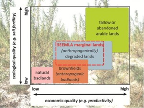
Launched in 2016, the EU-funded project “Sustainable exploitation of biomass for bioenergy from marginal lands” (SEEMLA) aims at establishing suitable innovative land-use strategies for a sustainable production of bioenergy on marginal lands while improving general ecosystem services. Therefore, as one of the first tasks, SEEMLA faced the problem of general understanding of “marginal land” concept and its limitations, considering other relevant approaches. Various definitions of marginal lands can be found in scientific literature which mainly reflect the nature of land use and do not provide any information about environmental or economic qualities. Set aside from agricultural practice, marginal lands have been called, e.g., ‘idle’, ‘abandoned’, ‘surplus’, ‘degraded’, ‘waste’ or ‘set-aside’. The approach of SEEMLA focuses on sites mainly affected by anthropogenic degradation, i.e. mismanagement of land (see Figure 1).
According to the SEEMLA definition, marginal lands do not include sites with potentially high productivity which were set aside or were temporarily abandoned due to certain socio-economic reasons. In addition, lands with naturally extremely low soil fertility as well as most parts of brownfields or anthropogenic, highly contaminated wastelands are also not contemplated by SEEMLA. Conflicts related to other land-use options, such as nature conservation, forestry or agriculture, hence are expected to be minimized when underutilized land is selected for future biomass production. In addition to environmental and economic constraints, a comprehensive list of legislative limitations within the European countries was compiled by SEEMLA to illustrate pending political decisions with respect to utilizing marginal lands. Currently, there is not an official EU definition for marginal lands nor the potential use of marginal lands has been specified on the regional, national and EU level. However, it is the aim of SEEMLA to offer policy recommendations that will also include the important aspect of using marginal lands for biomass production to provide sustainable bioenergy.
Assessing marginal lands – SQR and GIS as tools for quantifying marginality
Based on a method for quantifying soil fertility of arable land, the SEEMLA consortium was able to successfully assess the marginality of selected case study sites in Ukraine, Greece and Germany. It proposes an integrated approach which evaluates physical, environmental, socioeconomic and ecological factors through multi-criteria analysis and Geographic Information Systems (GIS) at European level. Soil quality was assessed by using the Müncheberg Soil Quality Rating (SQR) tool , being adapted by the SEEMLA partner Brandenburg Technical University (BTU) Cottbus-Senftenberg, Germany. The application of the Müncheberg Soil Quality Rating (SQR) tool allows an easy access to a large number of different marginality criteria and indicators similar to those elaborated for identifying severe natural constraints to agriculture in the EU (Areas with Natural Constraints, ANC). The SQR incorporates soil quality, topography (slope) and climate (soil thermal & moisture regimes) factors, categorized as either basic or hazard indicators (HI). SQR scores range from 0 (very poor soil conditions) to 100 (very good soil conditions). Land of poor (20<SQR<40) or very poor (SQR<20) soil quality is considered marginal within the SEEMLA context.
The application of the SQR method at the case study sites of the project allowed for the discrimination of three groups of marginal lands:
1. abandoned arable lands that are frequently found in Eastern European countries and offer some potential for agriculture, but their fertility is usually clearly limited in comparison with other sites;
2. mountainous sites (particularly in Mediterranean regions) often exhibiting very shallow rooting depth due to degradation by erosion processes;
3. post-mining sites (investigated in Eastern German lignite mines) being characterized by very low humus and nutrient contents and partly by extreme acidification potentials.
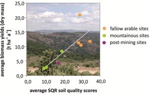
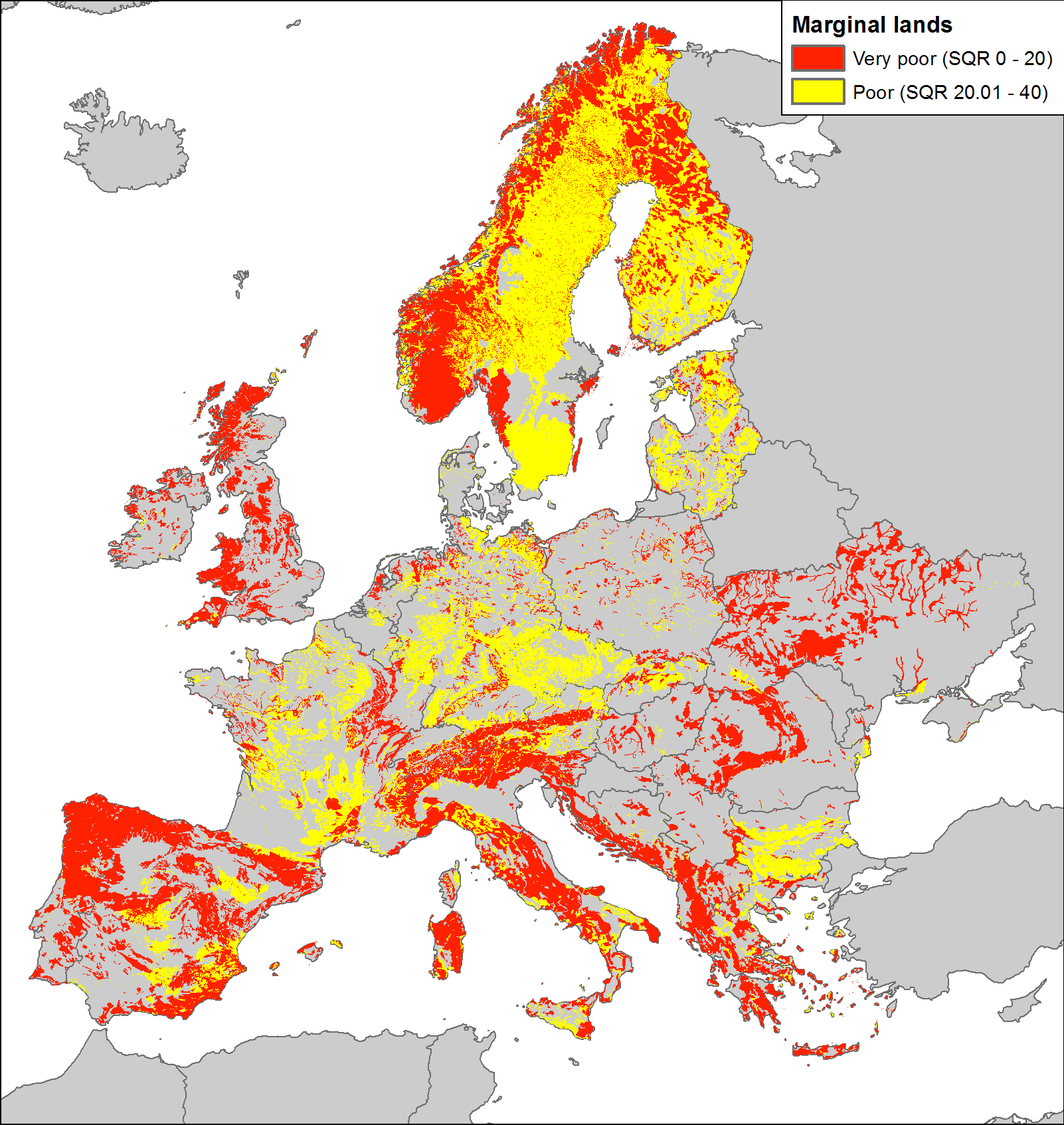
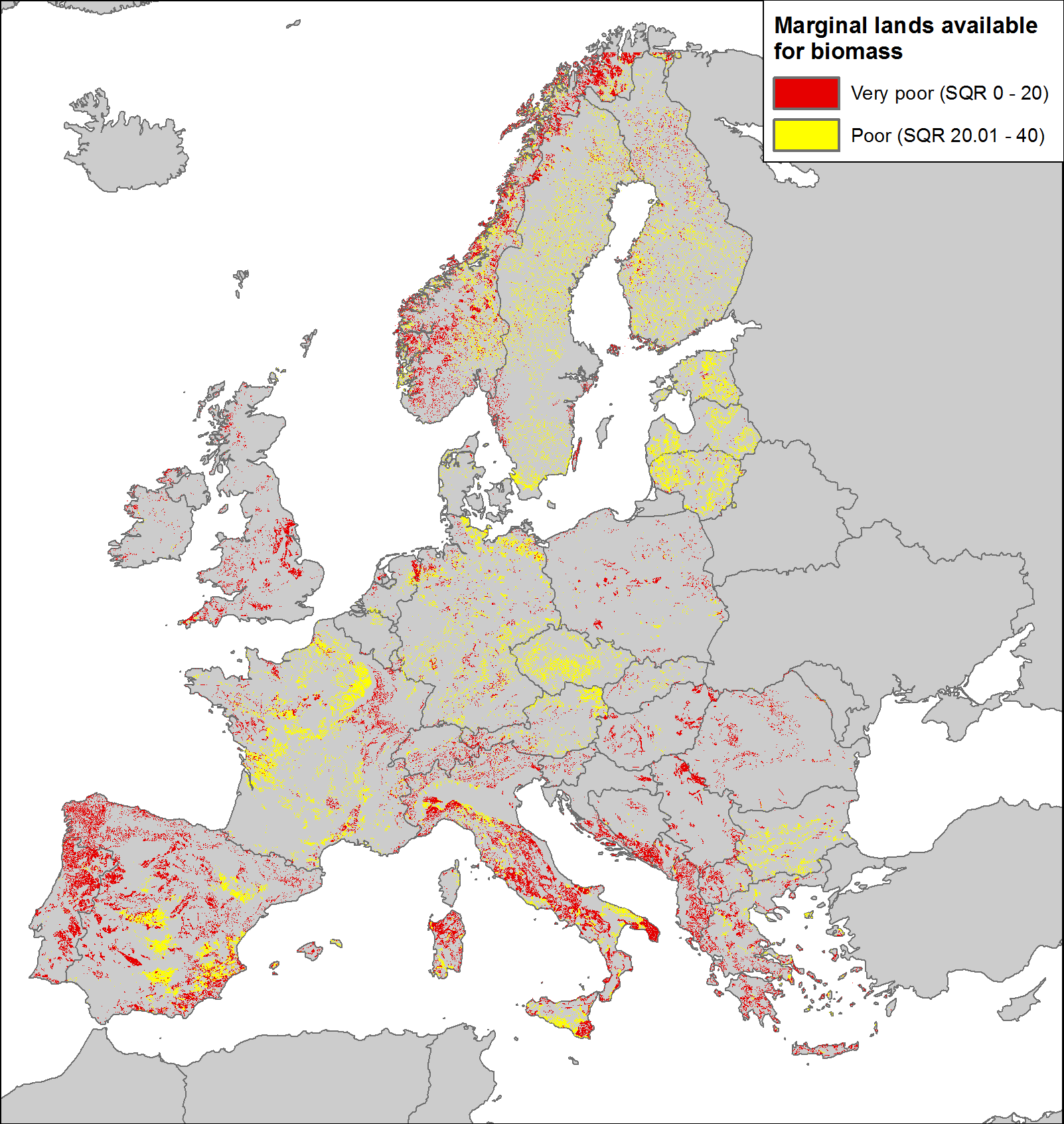
Figure 2 illustrates the relationship between soil fertility as quantified by means of SQR scores and average biomass yields for different bioenergy plants of SEEMLA case study sites in Europe. To identify marginal lands Europewide a GIS tool has been developed on the ESRI ArcGIS platform. Pan-European datasets of the European Soil Data Centre (ESDAC) have been primarily used to calculate the values of all basic indicators and ten soil hazard indicators. Moreover, data from the Harmonized World Soil Database were used for areas or parameters not covered by the ESDAC datasets, especially for Ukraine. Global elevation (SRTM) and climate (WorldClim) datasets were also included in the inputs of the ArcGIS tool to identify marginal land (Figure 3). It should be noted that the resolution of the input datasets varies from 250 m to 5 km which greatly affects the accuracy of the output. Using available environmental data – soil-related, topographic and climate data – and excluding unsuitable sites (e.g. classified areas for nature conservation), it was possible to give a first quantification of marginal lands in Europe. According to preliminary SQR results (Figure 3), 45 % of Europe is covered by marginal lands (220 Mha), however, only 13 % (63 Mha) is available for biomass production (Figure 4). This reduced number of potentially available marginal lands reflects considerations regarding nature conservation or restrictions due to other applied policies or constraints related to land use.
Utilizing marginal lands – a strategy for biomass production
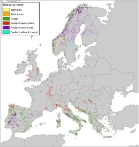
The SEEMLA project focuses on a sustainable re-conversion of marginal lands to produce bioenergy. One central objective of the SEEMLA approach is to provide producers who are interested in growing biomass with information about bioenergy crops suitable for specific site conditions. Part of the SEEMLA action, therefore, consisted in the elaboration of a catalogue of bioenergy crops and of corresponding technologies for planting, harvesting and utilizing these crops. The SEEMLA GIS tool includes the information from the catalogue and can suggest suitable bioenergy crops for selected sites, considering the respective marginality factors (Figure 5).
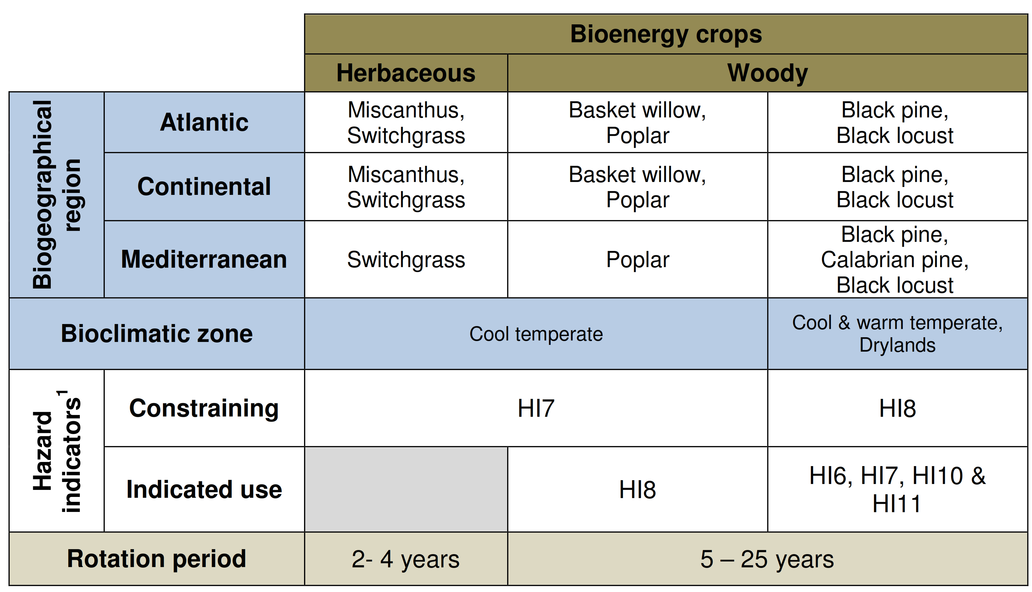
The lignocellulosic bioenergy crops selected for the SEEMLA project include both herbaceous crops, e.g. Miscanthus and switchgrass, and woody crops, e.g. basket willow, poplar, black locust, black pine and Calabrian pine. Therefore, the site specific selection of bioenergy crops depends on site characteristics, biogeographical region and the foreseen end-use of the biomass produced. The application of such constraints greatly decreases the marginal land that can be used to sustainably produce biomass for bioenergy. Despite of this, the estimated area, especially in Mediterranean countries, is expected to be enough to sustain biomass production at industrial scale. Hazard indicators act as constraints for the use of specific bioenergy crops and point towards the ones being more productive under given circumstances. Therefore, selecting the most suitable species to these extreme conditions is really important to sustainable biomass production: consequently, SEEMLA project developed a matrix to facilitate the selection of bioenergy crops (Table 1).
Another aspect of bioenergy crops to be considered is that of biomass features. Even though herbaceous crops generally provide higher biomass yields per year in comparison with woody crops, they tend to have higher ash content, a characteristic that constraints their use for pellet production. The enduse of the biomass should be hence considered during the selection of the crop species. Moreover, biomass production using perennial crops can also provide environmental services, such as land restoration through erosion control and soil structural development.
Land marginality may constitute a transitional state in these cases, due to dynamic soil characteristics. Furthermore, marginal land should not be considered as a mere dormant natural resource waiting to be used, since it may provide multiple benefits and services to society relating to wildlife, biodiversity or carbon sequestration.
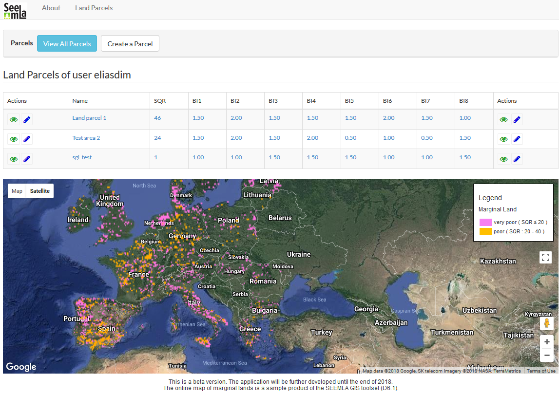
To determine land marginality at parcel level, the SEEMLA consortium developed a web application. It is an open-access tool that allows users to perform several calculations in an easy manner, resulting in the identification of marginal lands, their primary land marginality factor and suitable crops. The SEEMLA web application incorporates SEEMLA GIS tool data and it functions as SQR calculator: both tools will be finalized at the end of the project, in December 2018.
This article is by Werner Gerwin, Frank Repmann, BTU, Germany; Spyridon Galatsidas, Nikos Gounaris, Despoina Vlachaki, Elias Dimitriadis, DUTH, Greece; Vadym Ivanina, IBC&SB, Ukraine; Christiane Volkmann, Wibke Baumgarten, FNR, Germany, SEEMLA Project.