

For a long time, marginal lands have been considered a promising alternative for sustainable production of bioenergy. Free of conflict with traditional food production, exploitation of marginal lands for bioenergy can also improve ecosystem services. However, there is still a series of issues that needs to be addressed before actually determining whether a marginal land can sustain production on industrial scale or not.
The uncertainty arising from marginal land classification and quantification is the major constraining factor for its potential use. Land marginality is determined by dynamic characteristics in many cases and may therefore constitute a transitional state. Also, marginal land should not be considered simply a dormant natural resource waiting for to be used, since it may already provide multiple benefits and services to society, relating to wildlife, biodiversity, etc.
The H2020-funded SEEMLA project addresses the need for tools to identify and assess the potential of marginal lands for biomass production, taking into account the interrelated land functions. It proposes an integrated approach, at European level, which evaluates physical, environmental, socio-economic and ecological factors through multi-criteria analysis and Geographic Information Systems (GIS).
A tool to identify marginal lands
The first step towards this direction was to clearly identify marginal lands. To that end, the SEEMLA project selected soil quality as the determining factor of land marginality. Soil quality is assessed using the Muencheberg Soil Quality Rating (SQR) tool adapted by the SEEMLA partner Brandenburg Technical University (BTU) Cottbus, Germany.
The SQR incorporates soil quality, topography (slope) and climate (soil thermal & moisture regimes) factors, categorized as either basic or hazard indicators (HI). SQR scores range from 0 (very poor soil conditions) to 100 (very good soil conditions). Land of poor (20<SQR<40) or very poor (SQR<20) soil quality is considered marginal within the SEEMLA context.
The SEEMLA GIS toolset was developed to:
- identify marginal land;
- map marginal land based on the SQR;
- identify marginal land that is potentially available for biomass production;
- map marginal land that is suitable for the cultivation of specific bioenergy crops under corresponding climatic conditions;
- identify the major hazard indicator (HI) that determines land marginality.
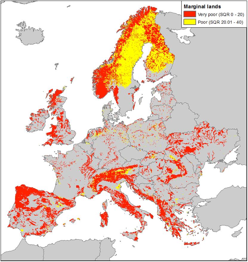
Pan-European datasets of the European Soil Data Center (ESDAC) have been primarily used to calculate the values of all basic indicators and ten soil hazard indicators. Moreover, data from the Harmonized World Soil Database were used for areas or parameters not covered by the ESDAC datasets, especially for Ukraine. Global elevation (SRTM) and climate (WorldClim) datasets were also included in the inputs of the ArcGIS tool to identify marginal land (Figure 1). It should be noted that the resolution of the input datasets varies from 250 m to 5 km which greatly affects the accuracy of the output.
Elimination criteria and application of hazardous indicators (HI)
According to preliminary results (Figure 1), 45 % of Europe is covered by marginal lands (220 Mha), however, only 13 % (63 Mha) is available for biomass production.
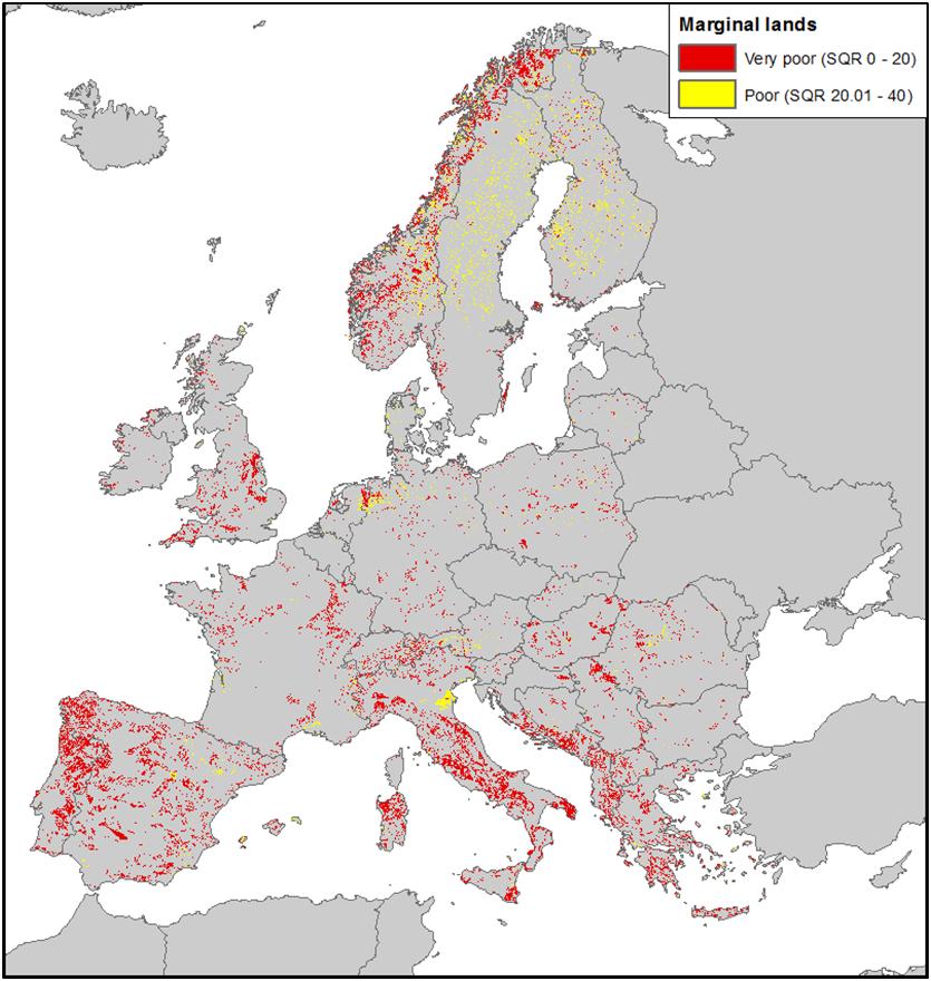
This reduced number of potentially available marginal lands reflects considerations regarding nature conservation or restrictions posed by other applied policies, which have also been incorporated in the GIS tool. Marginal lands within protected areas, such as sites of the NATURA 2000 network, are not considered suitable for biomass production and are therefore excluded. Other constraints are also applied, in relation to land use and sensitivity, resulting in marginal land that is actually available for biomass production (Figure 2).

Marginal lands and bioenergy crops
In addition, marginal land exploitability depends also on the bioenergy crop species to be cultivated. The specific biological demands of each crop species determine the types of marginal land where it can be cultivated. The lignocellulosic bioenergy crops selected for the SEEMLA project include both herbaceous crops, e.g. miscanthus and switchgrass, and woodycrops, e.g. basket willow, poplar, black locust, black pine and Calabrian pine. The site-specific selection of bioenergy crops depends on site characteristics, biogeographical region and the foreseen end-use of the biomass produced (Figure 3).
Each crop has specific ecological demands and constraining factors influencing its growth. The constraining factors are expressed by the hazard indicators (HI) of the SQR index. For example, willow is susceptible to drought (hazard indicator 7 – HI7) whereas Calabrian pine is highly drought resistant. Therefore, in areas where HI7 is the dominant marginality factor, drought resistant species like Calabrian pine should be used.
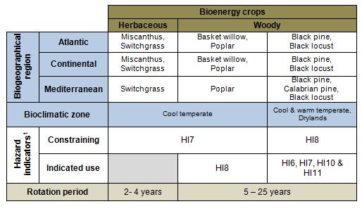
The application of such constraints greatly decreases the marginal land that can be used to sustainably produce biomass for bioenergy. Even so the estimated area, especially in Mediterranean countries, is expected to be enough to sustain biomass production at industrial scale. Hazard indicators act as constraints for the use of specific bioenergy crops, and also point towards the crops that will be more productive under the given circumstances. Land marginality due to extreme soil factors limits the growth of most crops.Therefore, selecting the species that is most adapted to these extreme conditions is key to sustainable biomass production.The SEEMLA project has developed a matrix to facilitate the selection of bioenergy crops (Table 1).
Biomass production considerations
Another aspect of bioenergy crops that needs to be considered is the properties of their biomass. Even though herbaceous crops generally provide higher biomass yields per year compared to woodycrops, they tend to have higher ash content, which constrains their use for pellet production. Hence, the end use of the biomass should be considered during the selection of the crop species.
Moreover, biomass production using perennial crops can also provide environmental services, such as land restoration through erosion control and soil structural development. Land marginality may constitute a transitional state in these cases, due to dynamic soil characteristics that can be reclaimed. Also, marginal land should not be considered simply a dormant natural resource waiting to be used, since it may already provide multiple benefits and services to society relating to wildlife, biodiversity or carbon sequestration.
Life cycle assessment (LCA), life cycle environmental impact assessment (LC-EIA), as well as an analysis of social and economic aspects, will determine the sustainability of each scenario, considering also the results of the pilot sites that have been established in Germany, Greece and Ukraine. These outcomes of the project will be incorporated to the GIS tool as well.
Altogether, the GIS tool provides an overall estimation of marginal land that is available for biomass production for bioenergy purposes in Europe, considering also environmental impacts, as well as socio-economic aspects.The resolution of the outputs is 1 km at pan–European scale, which can be (further) improved by using national datasets. However, in order to determine land marginality at parcel level another tool has been developed by the SEEMLA consortium: a web application.
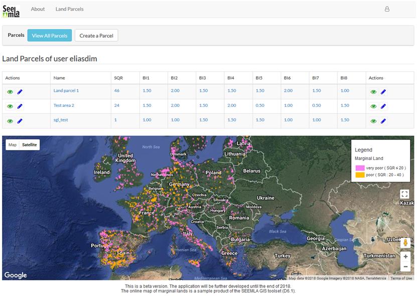
The SEEMLA web application functions as SQR calculator, which determines whether aland parcel is considered as marginal and, if so, which are appropriate bioenergy crops that can be grown there. It is an open access tool and allows the user to perform several calculations in an easy manner, resulting in the identification of marginal lands, their primary land marginality factor and suitable crops. The web application also incorporates the map of marginal lands produced by the SEEMLA GIS tool (Figure 4).
Both SEEMLA tools will be finalized at the end of the project, in December 2018.
For further information about the GIS-tool: www.seemla.eu; sgalatsi@fmenr.duth.gr
For further information about the project: www.seemla.eu; c.volkmann@fnr.de
Text by Dr. Spyridon Galatsidas, DUTH, Greece; Nikos Gounaris, DUTH, Greece; Despoina Vlachaki, DUTH, Greece; Elias Dimitriadis, DUTH, Greece; Dr. Christiane Volkmann, FNR, Germany; Dr. Wibke Baumgarten, FNR, Germany.
 This project has received funding from the European Union’s Horizon 2020 research and innovation programme under grant agreement No 691874.